

SALT LAKE CITY — A new storm set to move into northern Utah will bring even more snow, but will also create dangerous driving conditions with snow squalls in the forecast during evening commutes.
Winter Storm advisories and warnings have already been issued by the National Weather Service before the next round of snow begins Tuesday morning, with heavy snow forecast in the afternoon and early evening. The alerts are currently in effect from Tuesday morning until Thursday.

Total snow accumulations could reach up to two feet in the northern Wasatch Mountains, and up to 8 inches in the Cache Valley and eastern Box Elder County.
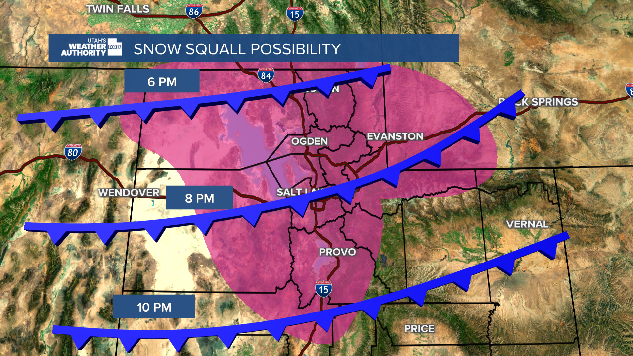
Of greater concern is the forecast calling for snow squalls during both the Tuesday and Wednesday evening commutes, with Cache Valley between Layton and Ogden considered a hazardous area. Snow squalls can cause sudden white-out conditions that create extremely dangerous conditions.
Most weather alerts issued for this weekend's storms expired Monday at 5 a.m., giving everyone a little break to clean up before the next storms take over.
Even though Monday will stay mostly clear, there could be some isolated snow showers during the morning hours. Snow will stay mostly in the mountains but lake effect showers are possible in Salt Lake and Tooele counties.
Across Utah, high temperatures are expected to remain below freezing.

However, some areas of Utah continued to get hit by winter storms Monday, with the San Juan School District opting for a virtual learning day or delayed start to school.
Check out the LATEST information on school closings and delays
During the Monday morning commute, icy road conditions made for a tough drive in some areas, specifically in Utah County. Several crashes were reported on the stretch of I-15 between American Fork and Lehi as commuters hit the road during the early morning hours.
Utah Highway Patrol told FOX 13 News that "multiple cars" were involved in separate crashes along the highway and a crew had been dispatched to quickly salt the road due to the slickness.
Though an exact number of incidents wasn't made available, the Utah Department of Transportation warned of more than five crashes in the area affecting both directions of traffic.
Crews were also hard at work Monday morning in Big and Little Cottonwood Canyons, with a mixture of snow and ice in lower canyon areas and a thick layer of packed snow in the middle and upper canyons.
Due to the dangerous driving conditions, the traction law was put in effect, meaning cars must be checked and properly equipped before heading into the canyons.
The messing morning commute comes after a weekend of storms that dropped several inches of snow across Utah.
Utah Highway Patrol was occupied through the entire weekend, with troopers reportedly responding to about 280 crashes from Friday through Saturday. Ice and snow contributed to especially difficult driving conditions across the state.
Another concern after the weekend of wintery weather is avalanche danger in the mountains. For Ogden area mountains, considerable avalanche danger exists due to the fresh powder. Salt Lake and Provo area mountains were reported to have moderate avalanche danger Monday.
Snow experts warned that conditions are just right for a human-triggered or natural avalanche, so recreators should be cautious when enjoying the greatest snow on earth.
Larger counties issued "Code Blue" protocol during the weekend due to the frigid conditions, opening shelters and overflows to help everyone stay warm during especially cold nights.
